Kirby night lights from space
Night Light of Kirby (Texas) from space (United States) Src. Average luminocity for 10x10km area is 90.0758% and for 50x50km: 54.6814%.
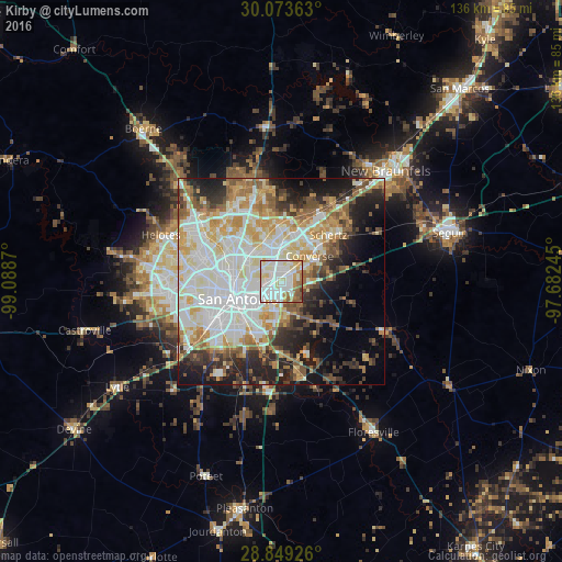
Analysis of Kirby night lights 2016
Square area 10x10 km:
 33.9%
33.9%90-99
35.61%80-89
9.09%70-79
7.39%60-69
7.77%50-59
5.3%40-49
0.57%30-39
0.38%20-29
0%10-19
0%0-9
0%Square area 50x50 km:
15.17%90-99
14.01%80-89
6.85%70-79
7.22%60-69
5.85%50-59
5.91%40-49
4.55%30-39
4.98%20-29
7.69%10-19
10.83%0-9
16.93%Clear (daylight) street map image can be seen on geolist.org.
Map coordinates:
30° 4' 25.1" North, 99° 5' 19.3" West
29° 27' 47.8" North, 98° 23' 8.1" West
28° 50' 57.3" North, 97° 40' 56.8" West
Some cities around Kirby sort by population:
• San Antonio
11.3 km =7 mi,  247°
247°
• Schertz
14.9 km =9.3 mi,  48°
48°
• Converse
9.1 km =5.7 mi, 47°
• Universal City
13.1 km =8.1 mi,  44°
44°
• Live Oak
12.3 km =7.6 mi,  22°
22°
• Alamo Heights
8.1 km =5 mi,  287°
287°
• Windcrest
5.8 km =3.6 mi,  5°
5°
• Terrell Hills
6.5 km =4 mi,  281°
281°
4703415 (p: 8,550)
Sources (retrieved 2019-11-25):
» Earth at Night: Flat Maps 2012, 2016