Terrell Hills night lights from space
Night Light of Terrell Hills (Texas) from space (United States) Src. Average luminocity for 10x10km area is 97.3807% and for 50x50km: 60.1438%.
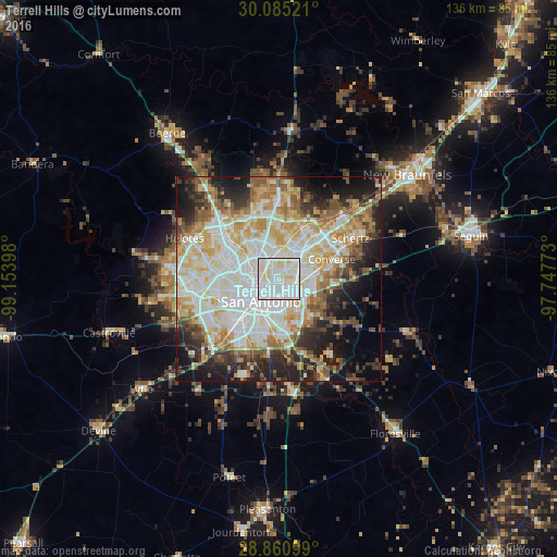
Analysis of Terrell Hills night lights 2016
Square area 10x10 km:
 53.98%
90-99
34.85%80-89
11.17%70-79
0%60-69
0%50-59
0%40-49
0%30-39
0%20-29
0%10-19
0%0-9
0%Square area 50x50 km:
16.54%90-99
15.5%80-89
7.89%70-79
8.15%60-69
6.17%50-59
6.61%40-49
5.14%30-39
5.56%20-29
8.38%10-19
11.3%0-9
8.77%Clear (daylight) street map image can be seen on geolist.org.
Map coordinates:
30° 5' 6.8" North, 99° 9' 14.3" West
29° 28' 29.8" North, 98° 27' 3.1" West
28° 51' 39.6" North, 97° 44' 51.8" West
Some cities around Terrell Hills sort by population:
• San Antonio
7 km =4.3 mi,  216°
216°
• Converse
13.9 km =8.6 mi,  69°
69°
• Universal City
17.5 km =10.9 mi,  62°
62°
• Live Oak
14.9 km =9.3 mi,  47°
47°
• Leon Valley
16.4 km =10.2 mi,  277°
277°
• Kirby
6.5 km =4 mi,  101°
101°
• Alamo Heights
1.8 km =1.1 mi,  307°
307°
• Windcrest
8.2 km =5.1 mi, 56°
4736043 (p: 5,287)
Sources (retrieved 2019-11-25):
» Earth at Night: Flat Maps 2012, 2016