Kings Park West night lights from space
Night Light of Kings Park West (Virginia) from space (United States) Src. Average luminocity for 10x10km area is 75.5918% and for 50x50km: 66.4945%.
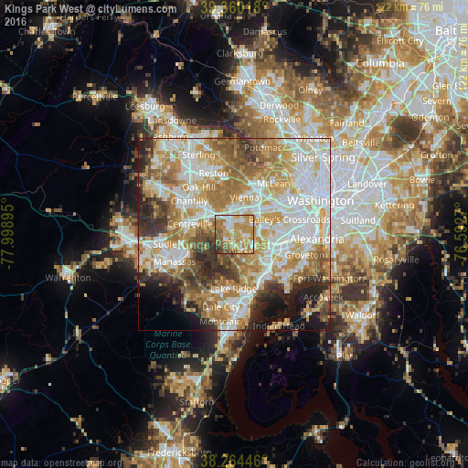
Analysis of Kings Park West night lights 2016
Square area 10x10 km:
 13.1%
13.1%90-99
14.46%80-89
7.99%70-79
29.76%60-69
18.54%50-59
10.2%40-49
3.06%30-39
2.38%20-29
0.51%10-19
0%0-9
0%Square area 50x50 km:
17.01%90-99
15.19%80-89
9.03%70-79
12.17%60-69
11.58%50-59
7.46%40-49
4.92%30-39
5.44%20-29
6.45%10-19
5.3%0-9
5.45%Clear (daylight) street map image can be seen on geolist.org.
Map coordinates:
39° 21' 36.6" North, 77° 59' 56.2" West
38° 48' 51.9" North, 77° 17' 45" West
38° 15' 52.1" North, 76° 35' 33.7" West
Some cities around Kings Park West sort by population:
• Burke
3.1 km =1.9 mi,  138°
138°
• Oakton
7.4 km =4.6 mi,  356°
356°
• Fairfax
3.7 km =2.3 mi,  345°
345°
• West Springfield
8 km =5 mi,  125°
125°
• Fairfax Station
3 km =1.9 mi,  239°
239°
• Woodburn
6.3 km =3.9 mi,  54°
54°
• North Springfield
8 km =5 mi,  98°
98°
• Mantua
5.4 km =3.4 mi,  35°
35°
7315398 (p: 13,390)
Sources (retrieved 2019-11-25):
» Earth at Night: Flat Maps 2012, 2016