Fairfax Station night lights from space
Night Light of Fairfax Station (Virginia) from space (United States) Src. Average luminocity for 10x10km area is 64.2636% and for 50x50km: 62.6829%.
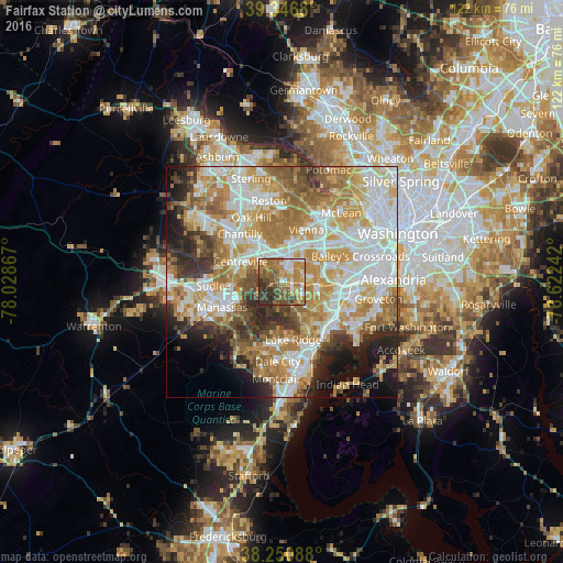
Analysis of Fairfax Station night lights 2016
Square area 10x10 km:
 7.31%
7.31%90-99
8.33%80-89
6.8%70-79
17.35%60-69
21.43%50-59
13.95%40-49
9.86%30-39
11.9%20-29
3.06%10-19
0%0-9
0%Square area 50x50 km:
15.05%90-99
14.24%80-89
8.41%70-79
11.64%60-69
11.44%50-59
7.08%40-49
4.69%30-39
5.61%20-29
6.64%10-19
6.7%0-9
8.49%Clear (daylight) street map image can be seen on geolist.org.
Map coordinates:
39° 20' 48.5" North, 78° 1' 43.2" West
38° 48' 3.4" North, 77° 19' 31.9" West
38° 15' 3.2" North, 76° 37' 20.7" West
Some cities around Fairfax Station sort by population:
• Centreville
10 km =6.2 mi,  296°
296°
• Burke
4.7 km =2.9 mi,  100°
100°
• Oakton
9.1 km =5.7 mi,  13°
13°
• West Springfield
9.6 km =6 mi,  109°
109°
• Kings Park West
3 km =1.9 mi,  59°
59°
• Woodburn
9.3 km =5.8 mi, 56°
• Greenbriar
10.4 km =6.5 mi,  321°
321°
• Mantua
8.2 km =5.1 mi,  44°
44°
4758102 (p: 12,030)
Sources (retrieved 2019-11-25):
» Earth at Night: Flat Maps 2012, 2016