Keyes night lights from space
Night Light of Keyes (California) from space (United States) Src. Average luminocity for 10x10km area is 48.7127% and for 50x50km: 22.0667%.
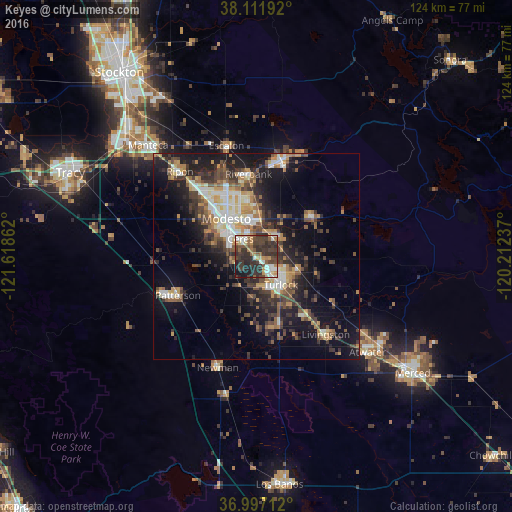
Analysis of Keyes night lights 2016
Square area 10x10 km:
 6.49%
6.49%90-99
7.47%80-89
3.9%70-79
5.68%60-69
6.33%50-59
7.31%40-49
12.66%30-39
22.56%20-29
21.43%10-19
6.01%0-9
0.16%Square area 50x50 km:
2.67%90-99
3.34%80-89
1.78%70-79
3.5%60-69
2.67%50-59
3.12%40-49
4.42%30-39
5.67%20-29
6.41%10-19
14.35%0-9
52.07%Clear (daylight) street map image can be seen on geolist.org.
Map coordinates:
38° 6' 42.9" North, 121° 37' 7" West
37° 33' 23.8" North, 120° 54' 55.8" West
36° 59' 49.6" North, 120° 12' 44.5" West
Some cities around Keyes sort by population:
• Modesto
11.6 km =7.2 mi,  321°
321°
• Turlock
9.2 km =5.7 mi,  138°
138°
• Ceres
5.7 km =3.5 mi, 318°
• Waterford
16.6 km =10.3 mi,  55°
55°
• Hughson
6.2 km =3.9 mi,  44°
44°
• West Modesto
12.8 km =8 mi,  301°
301°
• Hilmar-Irwin
17.9 km =11.1 mi,  161°
161°
• Bret Harte
9.4 km =5.8 mi, 302°
5363058 (p: 5,601)
Sources (retrieved 2019-11-25):
» Earth at Night: Flat Maps 2012, 2016