West Modesto night lights from space
Night Light of West Modesto (California) from space (United States) Src. Average luminocity for 10x10km area is 54.3418% and for 50x50km: 24.7497%.
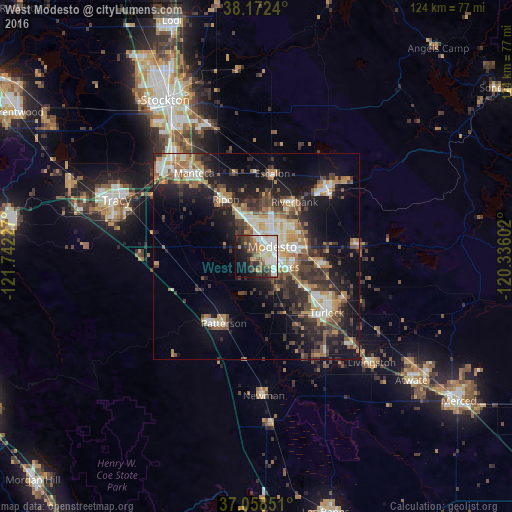
Analysis of West Modesto night lights 2016
Square area 10x10 km:
 12.76%
90-99
15.48%80-89
4.42%70-79
5.27%60-69
5.1%50-59
7.48%40-49
8.33%30-39
9.69%20-29
8.33%10-19
13.78%0-9
9.35%Square area 50x50 km:
3.31%90-99
4.03%80-89
1.91%70-79
4.06%60-69
3.35%50-59
3.37%40-49
4.51%30-39
5.61%20-29
7.4%10-19
14.67%0-9
47.77%Clear (daylight) street map image can be seen on geolist.org.
Map coordinates:
38° 10' 20.6" North, 121° 44' 32.2" West
37° 37' 3.1" North, 121° 2' 20.9" West
37° 3' 30.6" North, 120° 20' 9.7" West
Some cities around West Modesto sort by population:
• Modesto
4.4 km =2.7 mi,  57°
57°
• Ceres
7.6 km =4.7 mi,  109°
109°
• Riverbank
16 km =9.9 mi,  34°
34°
• Ripon
15.7 km =9.8 mi,  331°
331°
• Salida
10.6 km =6.6 mi,  337°
337°
• Hughson
15.4 km =9.6 mi,  98°
98°
• Keyes
12.8 km =8 mi,  121°
121°
• Bret Harte
3.4 km =2.1 mi, 119°
7262504 (p: 5,682)
Sources (retrieved 2019-11-25):
» Earth at Night: Flat Maps 2012, 2016