Hilmar-Irwin night lights from space
Night Light of Hilmar-Irwin (California) from space (United States) Src. Average luminocity for 10x10km area is 25.7808% and for 50x50km: 14.0278%.
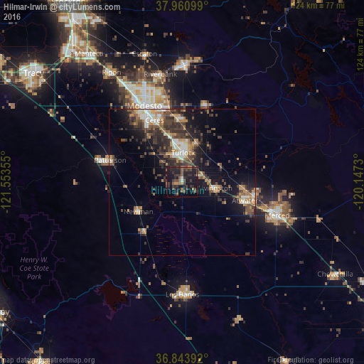
Analysis of Hilmar-Irwin night lights 2016
Square area 10x10 km:
 0%
0%90-99
1.46%80-89
0.16%70-79
2.6%60-69
2.6%50-59
8.12%40-49
6.82%30-39
12.99%20-29
14.61%10-19
30.52%0-9
20.13%Square area 50x50 km:
1.14%90-99
1.76%80-89
0.86%70-79
2.33%60-69
1.81%50-59
2.31%40-49
3.36%30-39
4.25%20-29
4.29%10-19
9.13%0-9
68.76%Clear (daylight) street map image can be seen on geolist.org.
Map coordinates:
37° 57' 39.6" North, 121° 33' 12.8" West
37° 24' 16.3" North, 120° 51' 1.5" West
36° 50' 38.1" North, 120° 8' 50.3" West
Some cities around Hilmar-Irwin sort by population:
• Turlock
10 km =6.2 mi,  1°
1°
• Livingston
11.4 km =7.1 mi,  99°
99°
• Newman
18.1 km =11.2 mi,  236°
236°
• Delhi
7.1 km =4.4 mi,  64°
64°
• Winton
21 km =13 mi,  94°
94°
• Hughson
21.4 km =13.3 mi,  356°
356°
• Gustine
20.9 km =13 mi,  218°
218°
• Keyes
17.9 km =11.1 mi,  341°
341°
7261441 (p: 5,197)
Sources (retrieved 2019-11-25):
» Earth at Night: Flat Maps 2012, 2016