Jordan night lights from space
Night Light of Jordan (Minnesota) from space (United States) Src. Average luminocity for 10x10km area is 9.8758% and for 50x50km: 17.1087%.
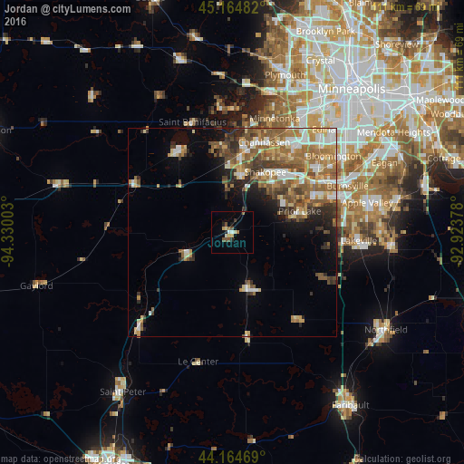
Analysis of Jordan night lights 2016
Square area 10x10 km:
 0.76%
0.76%90-99
1.82%80-89
0.45%70-79
1.67%60-69
0.91%50-59
1.97%40-49
2.12%30-39
0.61%20-29
1.67%10-19
0.76%0-9
87.27%Square area 50x50 km:
2.41%90-99
2.54%80-89
2.21%70-79
2.59%60-69
3.49%50-59
3.61%40-49
2.84%30-39
2.29%20-29
2.68%10-19
3.98%0-9
71.36%Clear (daylight) street map image can be seen on geolist.org.
Map coordinates:
45° 9' 53.4" North, 94° 19' 48.1" West
44° 40' 0.9" North, 93° 37' 36.8" West
44° 9' 52.9" North, 92° 55' 25.6" West
Some cities around Jordan sort by population:
• Shakopee
16.6 km =10.3 mi,  28°
28°
• Chanhassen
23 km =14.3 mi,  19°
19°
• Prior Lake
16.9 km =10.5 mi,  72°
72°
• Chaska
13.8 km =8.6 mi,  8°
8°
• Waconia
24 km =14.9 mi,  328°
328°
• Victoria
21.5 km =13.4 mi,  352°
352°
• New Prague
14.3 km =8.9 mi,  163°
163°
• Belle Plaine
12.2 km =7.6 mi,  246°
246°
5032106 (p: 6,076)
Sources (retrieved 2019-11-25):
» Earth at Night: Flat Maps 2012, 2016