Ione night lights from space
Night Light of Ione (California) from space (United States) Src. Average luminocity for 10x10km area is 9.9014% and for 50x50km: 2.5052%.
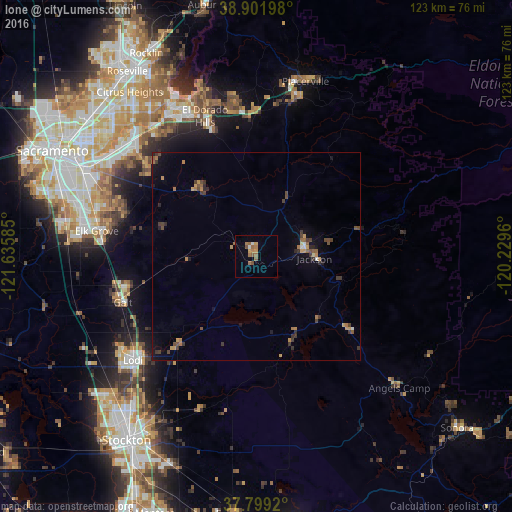
Analysis of Ione night lights 2016
Square area 10x10 km:
 0.68%
0.68%90-99
0.68%80-89
0%70-79
2.21%60-69
3.74%50-59
3.4%40-49
1.19%30-39
0%20-29
0%10-19
0%0-9
88.1%Square area 50x50 km:
0.07%90-99
0.12%80-89
0.07%70-79
0.6%60-69
0.49%50-59
0.47%40-49
0.55%30-39
0.72%20-29
0.38%10-19
0.87%0-9
95.67%Clear (daylight) street map image can be seen on geolist.org.
Map coordinates:
38° 54' 7.1" North, 121° 38' 9.1" West
38° 21' 9.7" North, 120° 55' 57.8" West
37° 47' 57.1" North, 120° 13' 46.6" West
Some cities around Ione sort by population:
• Elk Grove
38.8 km =24.1 mi,  279°
279°
• Lodi
38.6 km =24 mi,  230°
230°
• El Dorado Hills
39.2 km =24.4 mi,  340°
340°
• Galt
33.8 km =21 mi,  251°
251°
• Vineyard
38.2 km =23.7 mi,  289°
289°
• Cameron Park
35.5 km =22.1 mi,  352°
352°
• Rancho Murieta
21.8 km =13.5 mi,  319°
319°
• Wilton
30.3 km =18.8 mi, 282°
5359634 (p: 7,000)
Sources (retrieved 2019-11-25):
» Earth at Night: Flat Maps 2012, 2016