Hyattsville night lights from space
Night Light of Hyattsville (Maryland) from space (United States) Src. Average luminocity for 10x10km area is 98.1088% and for 50x50km: 78.5356%.
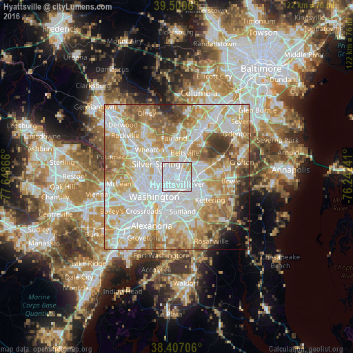
Analysis of Hyattsville night lights 2016
Square area 10x10 km:
 70.78%
90-99
21.59%80-89
5.19%70-79
2.44%60-69
0%50-59
0%40-49
0%30-39
0%20-29
0%10-19
0%0-9
0%Square area 50x50 km:
25.48%90-99
19.96%80-89
11.65%70-79
13.35%60-69
10.17%50-59
7.3%40-49
3.41%30-39
3.01%20-29
1.88%10-19
1.86%0-9
1.95%Clear (daylight) street map image can be seen on geolist.org.
Map coordinates:
39° 30' 2.2" North, 77° 38' 55.2" West
38° 57' 21.4" North, 76° 56' 43.9" West
38° 24' 25.4" North, 76° 14' 32.7" West
Some cities around Hyattsville sort by population:
• Chillum
4 km =2.5 mi,  282°
282°
• College Park
2.8 km =1.7 mi,  15°
15°
• East Riverdale
2.2 km =1.4 mi,  71°
71°
• Bladensburg
2.1 km =1.3 mi,  151°
151°
• Mount Rainier
2.3 km =1.4 mi,  226°
226°
• Riverdale Park
1.5 km =0.9 mi,  55°
55°
• Cheverly
4 km =2.5 mi,  140°
140°
• Woodlawn
4.7 km =2.9 mi,  98°
98°
4358821 (p: 18,501)
Sources (retrieved 2019-11-25):
» Earth at Night: Flat Maps 2012, 2016