Hudson night lights from space
Night Light of Hudson (New Hampshire) from space (United States) Src. Average luminocity for 10x10km area is 54.9788% and for 50x50km: 29.8263%.
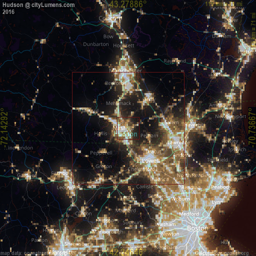
Analysis of Hudson night lights 2016
Square area 10x10 km:
 9.85%
9.85%90-99
11.97%80-89
2.73%70-79
12.42%60-69
7.58%50-59
9.24%40-49
10.45%30-39
6.97%20-29
11.36%10-19
16.52%0-9
0.91%Square area 50x50 km:
3.52%90-99
4.7%80-89
3.33%70-79
3.36%60-69
4.97%50-59
7.08%40-49
5.36%30-39
4.89%20-29
8.56%10-19
16.22%0-9
38.01%Clear (daylight) street map image can be seen on geolist.org.
Map coordinates:
43° 16' 43.9" North, 72° 8' 34.5" West
42° 45' 53.3" North, 71° 26' 23.2" West
42° 14' 47.3" North, 70° 44' 12" West
Some cities around Hudson sort by population:
• Nashua
2.3 km =1.4 mi,  271°
271°
• Merrimack
12 km =7.5 mi,  338°
338°
• Windham
11.8 km =7.3 mi,  70°
70°
• Pelham
10 km =6.2 mi,  109°
109°
• Tyngsboro
9.9 km =6.2 mi,  172°
172°
• Londonderry
12.4 km =7.7 mi,  25°
25°
• Litchfield
9.4 km =5.8 mi, 339°
• Hollis
12.6 km =7.8 mi,  259°
259°
5087752 (p: 7,336)
Sources (retrieved 2019-11-25):
» Earth at Night: Flat Maps 2012, 2016