Windham night lights from space
Night Light of Windham (New Hampshire) from space (United States) Src. Average luminocity for 10x10km area is 23.2015% and for 50x50km: 32.8168%.
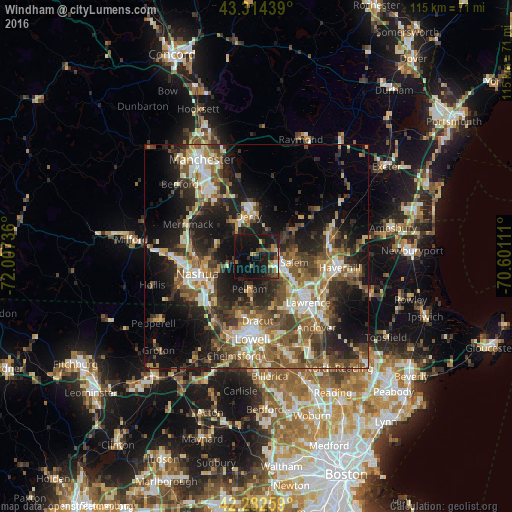
Analysis of Windham night lights 2016
Square area 10x10 km:
 1.52%
1.52%90-99
1.36%80-89
1.52%70-79
3.18%60-69
2.88%50-59
3.79%40-49
3.79%30-39
4.55%20-29
9.09%10-19
39.39%0-9
28.94%Square area 50x50 km:
3.86%90-99
5.17%80-89
3.8%70-79
3.93%60-69
5.07%50-59
6.89%40-49
6.54%30-39
5.83%20-29
10.19%10-19
17.44%0-9
31.29%Clear (daylight) street map image can be seen on geolist.org.
Map coordinates:
43° 18' 51.8" North, 72° 0' 26.5" West
42° 48' 2.3" North, 71° 18' 15.2" West
42° 16' 57.3" North, 70° 36' 4" West
Some cities around Windham sort by population:
• Methuen
12.4 km =7.7 mi,  131°
131°
• Derry Village
10.2 km =6.3 mi,  356°
356°
• Salem
8.5 km =5.3 mi,  99°
99°
• Derry
9.1 km =5.7 mi,  348°
348°
• Pelham
7.5 km =4.7 mi,  192°
192°
• Londonderry
9.1 km =5.7 mi,  321°
321°
• Hampstead
13 km =8.1 mi,  50°
50°
• Hudson
11.8 km =7.3 mi,  250°
250°
5094817 (p: 13,091)
Sources (retrieved 2019-11-25):
» Earth at Night: Flat Maps 2012, 2016