Homestead Meadows North night lights from space
Night Light of Homestead Meadows North (Texas) from space (United States) Src. Average luminocity for 10x10km area is 24.37% and for 50x50km: 25.3703%.
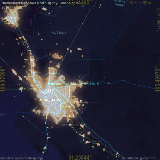
Analysis of Homestead Meadows North night lights 2016
Square area 10x10 km:
 0%
0%90-99
0.73%80-89
2.38%70-79
9.89%60-69
3.85%50-59
5.13%40-49
4.03%30-39
2.93%20-29
8.06%10-19
19.05%0-9
43.96%Square area 50x50 km:
7.19%90-99
4.67%80-89
4.26%70-79
5.82%60-69
2.43%50-59
1.47%40-49
1.66%30-39
1.58%20-29
3%10-19
5.91%0-9
62.01%Clear (daylight) street map image can be seen on geolist.org.
Map coordinates:
32° 26' 41.8" North, 106° 52' 33.5" West
31° 50' 58.7" North, 106° 10' 22.3" West
31° 15' 1.6" North, 105° 28' 11" West
Some cities around Homestead Meadows North sort by population:
• Juárez, MX
30.8 km =19.1 mi,  242°
242°
• El Paso
31.4 km =19.5 mi,  251°
251°
• Socorro
25 km =15.5 mi,  209°
209°
• Socorro Mission Number 1 Colonia
26.2 km =16.3 mi, 205°
• Horizon City
17.8 km =11.1 mi,  190°
190°
• Chaparral
27.9 km =17.3 mi,  313°
313°
• San Elizario
30.9 km =19.2 mi,  197°
197°
• Fort Bliss
23 km =14.3 mi,  259°
259°
5523335 (p: 5,124)
Sources (retrieved 2019-11-25):
» Earth at Night: Flat Maps 2012, 2016