Fort Bliss night lights from space
Night Light of Fort Bliss (Texas) from space (United States) Src. Average luminocity for 10x10km area is 92.3462% and for 50x50km: 46.0184%.
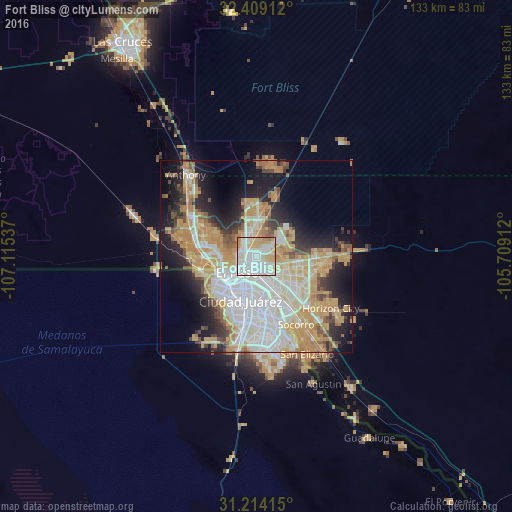
Analysis of Fort Bliss night lights 2016
Square area 10x10 km:
 37.18%
90-99
33.88%80-89
9.34%70-79
15.93%60-69
3.11%50-59
0.55%40-49
0%30-39
0%20-29
0%10-19
0%0-9
0%Square area 50x50 km:
13.11%90-99
8%80-89
6.09%70-79
10.77%60-69
5.52%50-59
3.13%40-49
3.61%30-39
3.04%20-29
6.97%10-19
12.08%0-9
27.69%Clear (daylight) street map image can be seen on geolist.org.
Map coordinates:
32° 24' 32.8" North, 107° 6' 55.3" West
31° 48' 48.9" North, 106° 24' 44.1" West
31° 12' 50.9" North, 105° 42' 32.8" West
Some cities around Fort Bliss sort by population:
• Juárez, MX
11.3 km =7 mi,  203°
203°
• El Paso
9.3 km =5.8 mi,  229°
229°
• Socorro
20.5 km =12.7 mi,  149°
149°
• Socorro Mission Number 1 Colonia
22.8 km =14.2 mi, 149°
• Sunland Park
16 km =9.9 mi,  263°
263°
• Homestead Meadows South
23.4 km =14.5 mi,  90°
90°
• Canutillo
20.8 km =12.9 mi,  301°
301°
• Homestead Meadows North
23 km =14.3 mi,  79°
79°
7261282 (p: 8,591)
Sources (retrieved 2019-11-25):
» Earth at Night: Flat Maps 2012, 2016