Delhi night lights from space
Night Light of Delhi (California) from space (United States) Src. Average luminocity for 10x10km area is 27.0487% and for 50x50km: 16.8086%.
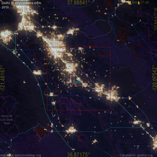
Analysis of Delhi night lights 2016
Square area 10x10 km:
 0.65%
0.65%90-99
2.27%80-89
1.14%70-79
4.71%60-69
1.46%50-59
3.57%40-49
10.88%30-39
10.55%20-29
7.14%10-19
46.1%0-9
11.53%Square area 50x50 km:
1.76%90-99
2.31%80-89
1.07%70-79
2.69%60-69
2.46%50-59
2.64%40-49
3.68%30-39
4.5%20-29
5.26%10-19
10.21%0-9
63.41%Clear (daylight) street map image can be seen on geolist.org.
Map coordinates:
37° 59' 18.3" North, 121° 28' 54" West
37° 25' 55.8" North, 120° 46' 42.7" West
36° 52' 18.3" North, 120° 4' 31.5" West
Some cities around Delhi sort by population:
• Turlock
9.2 km =5.7 mi,  319°
319°
• Atwater
17.7 km =11 mi,  122°
122°
• Livingston
7 km =4.3 mi,  136°
136°
• Winton
15.4 km =9.6 mi,  108°
108°
• Waterford
23.3 km =14.5 mi,  3°
3°
• Hughson
19.9 km =12.4 mi,  337°
337°
• Keyes
18.4 km =11.4 mi, 318°
• Hilmar-Irwin
7.1 km =4.4 mi,  244°
244°
5342522 (p: 10,755)
Sources (retrieved 2019-11-25):
» Earth at Night: Flat Maps 2012, 2016