Hazel Park night lights from space
Night Light of Hazel Park (Michigan) from space (United States) Src. Average luminocity for 10x10km area is 99.3556% and for 50x50km: 81.4319%.
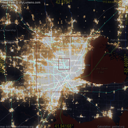
Analysis of Hazel Park night lights 2016
Square area 10x10 km:
 78.57%
90-99
20.48%80-89
0.95%70-79
0%60-69
0%50-59
0%40-49
0%30-39
0%20-29
0%10-19
0%0-9
0%Square area 50x50 km:
36.06%90-99
22.6%80-89
7.69%70-79
8.54%60-69
8.81%50-59
4.63%40-49
1.83%30-39
1.36%20-29
2.27%10-19
2.84%0-9
3.36%Clear (daylight) street map image can be seen on geolist.org.
Map coordinates:
42° 58' 44.8" North, 83° 48' 26" West
42° 27' 45.1" North, 83° 6' 14.7" West
41° 56' 30" North, 82° 24' 3.5" West
Some cities around Hazel Park sort by population:
• Royal Oak
4.5 km =2.8 mi,  312°
312°
• Madison Heights
2.6 km =1.6 mi,  357°
357°
• Oak Park
6.5 km =4 mi,  266°
266°
• Ferndale
2.5 km =1.6 mi, 265°
• Berkley
7.9 km =4.9 mi,  304°
304°
• Highland Park
6.4 km =4 mi,  174°
174°
• Center Line
6.7 km =4.2 mi,  68°
68°
• Huntington Woods
5.5 km =3.4 mi,  291°
291°
4995664 (p: 16,597)
Sources (retrieved 2019-11-25):
» Earth at Night: Flat Maps 2012, 2016