Harrison night lights from space
Night Light of Harrison (Tennessee) from space (United States) Src. Average luminocity for 10x10km area is 56.3007% and for 50x50km: 33.5444%.
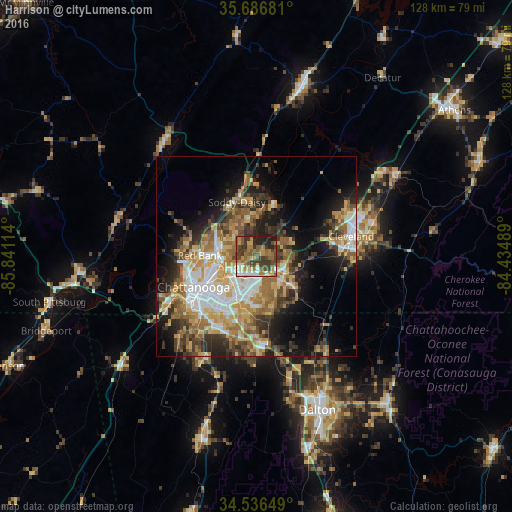
Analysis of Harrison night lights 2016
Square area 10x10 km:
 5.94%
5.94%90-99
5.77%80-89
6.64%70-79
10.49%60-69
14.69%50-59
13.99%40-49
13.11%30-39
15.73%20-29
12.41%10-19
1.22%0-9
0%Square area 50x50 km:
5.46%90-99
4.95%80-89
5.06%70-79
5.55%60-69
6.17%50-59
5.14%40-49
4.19%30-39
6.55%20-29
6.62%10-19
11.03%0-9
39.27%Clear (daylight) street map image can be seen on geolist.org.
Map coordinates:
35° 41' 12.5" North, 85° 50' 28.1" West
35° 6' 49.2" North, 85° 8' 16.8" West
34° 32' 11.4" North, 84° 26' 5.6" West
Some cities around Harrison sort by population:
• Chattanooga
17.4 km =10.8 mi,  244°
244°
• East Chattanooga
11.4 km =7.1 mi, 242°
• East Ridge
15.2 km =9.4 mi,  223°
223°
• East Brainerd
13.1 km =8.1 mi,  184°
184°
• Soddy-Daisy
14.4 km =8.9 mi,  340°
340°
• Middle Valley
10.1 km =6.3 mi, 335°
• Red Bank
14.2 km =8.8 mi,  269°
269°
• Collegedale
10.4 km =6.5 mi,  130°
130°
4627983 (p: 7,769)
Sources (retrieved 2019-11-25):
» Earth at Night: Flat Maps 2012, 2016