Harrisburg night lights from space
Night Light of Harrisburg (South Dakota) from space (United States) Src. Average luminocity for 10x10km area is 17.2762% and for 50x50km: 12.0397%.
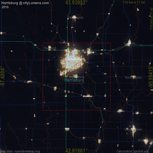
Analysis of Harrisburg night lights 2016
Square area 10x10 km:
 0.32%
0.32%90-99
0.79%80-89
1.9%70-79
2.86%60-69
0.16%50-59
2.22%40-49
4.13%30-39
5.08%20-29
14.92%10-19
15.87%0-9
51.75%Square area 50x50 km:
2.27%90-99
2.86%80-89
1.74%70-79
1.21%60-69
1.43%50-59
1.12%40-49
1.26%30-39
1.35%20-29
2.94%10-19
5.15%0-9
78.68%Clear (daylight) street map image can be seen on geolist.org.
Map coordinates:
43° 56' 23.4" North, 97° 24' 1.4" West
43° 25' 52.9" North, 96° 41' 50.2" West
42° 55' 7" North, 95° 59' 38.9" West
Some cities around Harrisburg sort by population:
• Sioux Falls
13.2 km =8.2 mi,  358°
358°
• Vermillion
74.9 km =46.5 mi,  194°
194°
• Brandon
20.8 km =12.9 mi,  29°
29°
• Le Mars
83 km =51.6 mi,  148°
148°
• Sioux Center
57.6 km =35.8 mi,  132°
132°
• Madison
72.1 km =44.8 mi,  332°
332°
• Orange City
70 km =43.5 mi, 132°
• Sheldon
73.5 km =45.7 mi,  112°
112°
5228340 (p: 5,498)
Sources (retrieved 2019-11-25):
» Earth at Night: Flat Maps 2012, 2016