Grissom Air Force Base night lights from space
Night Light of Grissom Air Force Base (Indiana) from space (United States) Src. Average luminocity for 10x10km area is 17.1558% and for 50x50km: 8.3192%.
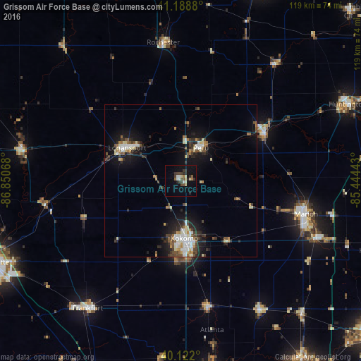
Analysis of Grissom Air Force Base night lights 2016
Square area 10x10 km:
 2.11%
2.11%90-99
1.46%80-89
2.76%70-79
0.65%60-69
1.46%50-59
1.62%40-49
2.92%30-39
5.84%20-29
3.57%10-19
12.34%0-9
65.26%Square area 50x50 km:
1.2%90-99
1.43%80-89
0.95%70-79
0.6%60-69
0.82%50-59
0.96%40-49
1.29%30-39
1.44%20-29
2.29%10-19
6.27%0-9
82.75%Clear (daylight) street map image can be seen on geolist.org.
Map coordinates:
41° 11' 19.7" North, 86° 51' 2.4" West
40° 39' 27.1" North, 86° 8' 51.2" West
40° 7' 19.2" North, 85° 26' 39.9" West
Some cities around Grissom Air Force Base sort by population:
• Kokomo
19.1 km =11.9 mi,  176°
176°
• Marion
42.7 km =26.5 mi,  104°
104°
• Logansport
20.7 km =12.9 mi,  301°
301°
• Peru
12.6 km =7.8 mi,  31°
31°
• Wabash
31.7 km =19.7 mi,  60°
60°
• Mount Vernon
27.3 km =17 mi,  87°
87°
• Rochester
45.6 km =28.3 mi,  352°
352°
• Tipton
42.7 km =26.5 mi,  167°
167°
7259295 (p: 5,537)
Sources (retrieved 2019-11-25):
» Earth at Night: Flat Maps 2012, 2016