Rochester night lights from space
Night Light of Rochester (Indiana) from space (United States) Src. Average luminocity for 10x10km area is 14.8506% and for 50x50km: 1.3715%.
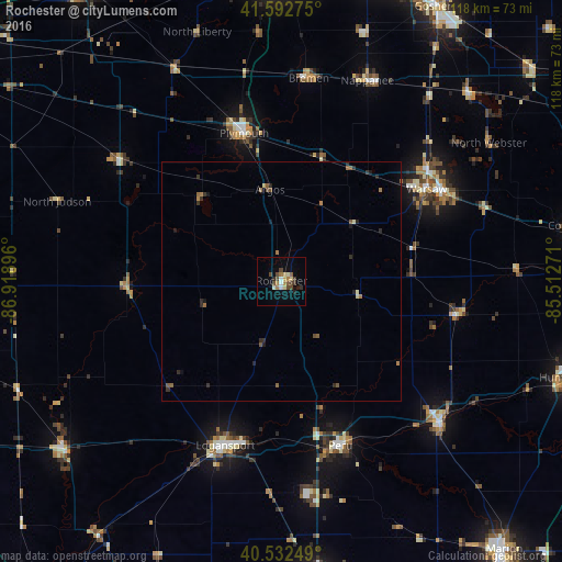
Analysis of Rochester night lights 2016
Square area 10x10 km:
 0.49%
0.49%90-99
2.76%80-89
2.11%70-79
0.49%60-69
3.25%50-59
1.46%40-49
4.38%30-39
2.44%20-29
1.62%10-19
2.44%0-9
78.57%Square area 50x50 km:
0.02%90-99
0.15%80-89
0.14%70-79
0.05%60-69
0.36%50-59
0.31%40-49
0.28%30-39
0.28%20-29
0.44%10-19
0.31%0-9
97.67%Clear (daylight) street map image can be seen on geolist.org.
Map coordinates:
41° 35' 33.9" North, 86° 55' 8.3" West
41° 3' 53.1" North, 86° 12' 57" West
40° 31' 57" North, 85° 30' 45.8" West
Some cities around Rochester sort by population:
• Logansport
36.5 km =22.7 mi,  198°
198°
• Warsaw
36 km =22.4 mi,  57°
57°
• Peru
36.7 km =22.8 mi,  160°
160°
• Wabash
44.5 km =27.7 mi,  131°
131°
• Plymouth
32 km =19.9 mi,  345°
345°
• Nappanee
45.7 km =28.4 mi,  23°
23°
• North Manchester
38.2 km =23.7 mi,  100°
100°
• Grissom Air Force Base
45.6 km =28.3 mi,  172°
172°
4925519 (p: 6,065)
Sources (retrieved 2019-11-25):
» Earth at Night: Flat Maps 2012, 2016