Greenville night lights from space
Night Light of Greenville (Ohio) from space (United States) Src. Average luminocity for 10x10km area is 28.2045% and for 50x50km: 3.807%.
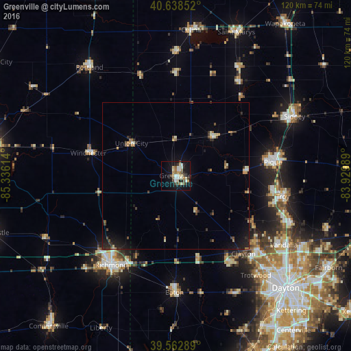
Analysis of Greenville night lights 2016
Square area 10x10 km:
 2.92%
2.92%90-99
8.44%80-89
3.41%70-79
0.81%60-69
4.87%50-59
2.92%40-49
3.25%30-39
3.25%20-29
3.57%10-19
30.03%0-9
36.53%Square area 50x50 km:
0.18%90-99
0.68%80-89
0.37%70-79
0.38%60-69
0.48%50-59
0.43%40-49
0.57%30-39
0.76%20-29
0.84%10-19
2.91%0-9
92.4%Clear (daylight) street map image can be seen on geolist.org.
Map coordinates:
40° 38' 18.7" North, 85° 20' 10.1" West
40° 6' 10.2" North, 84° 37' 58.8" West
39° 33' 46.4" North, 83° 55' 47.6" West
Some cities around Greenville sort by population:
• Richmond
37.5 km =23.3 mi,  215°
215°
• Troy
37.2 km =23.1 mi,  100°
100°
• Piqua
33.5 km =20.8 mi,  82°
82°
• Englewood
37.7 km =23.4 mi,  131°
131°
• Clayton
35.3 km =21.9 mi,  138°
138°
• Eaton
39.9 km =24.8 mi,  180°
180°
• Union
36 km =22.4 mi, 129°
• Brookville
35.1 km =21.8 mi,  147°
147°
5156493 (p: 13,006)
Sources (retrieved 2019-11-25):
» Earth at Night: Flat Maps 2012, 2016