Union night lights from space
Night Light of Union (Ohio) from space (United States) Src. Average luminocity for 10x10km area is 46.7143% and for 50x50km: 30.1525%.
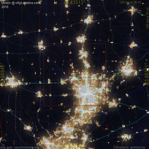
Analysis of Union night lights 2016
Square area 10x10 km:
 5.27%
5.27%90-99
6.29%80-89
6.29%70-79
6.46%60-69
6.29%50-59
8.33%40-49
11.39%30-39
15.82%20-29
13.61%10-19
18.71%0-9
1.53%Square area 50x50 km:
6.09%90-99
6.34%80-89
4.26%70-79
3.84%60-69
4.98%50-59
3.74%40-49
3.64%30-39
3.55%20-29
5.21%10-19
8.77%0-9
49.57%Clear (daylight) street map image can be seen on geolist.org.
Map coordinates:
40° 26' 6.5" North, 85° 0' 34.1" West
39° 53' 52.2" North, 84° 18' 22.8" West
39° 21' 22.6" North, 83° 36' 11.6" West
Some cities around Union sort by population:
• Trotwood
11.2 km =7 mi,  182°
182°
• Vandalia
9.2 km =5.7 mi,  95°
95°
• Englewood
2.3 km =1.4 mi,  171°
171°
• Clayton
6 km =3.7 mi,  230°
230°
• Shiloh
11 km =6.8 mi,  142°
142°
• Tipp City
13.3 km =8.3 mi,  59°
59°
• Northridge
13.7 km =8.5 mi, 137°
• Brookville
11.2 km =7 mi, 232°
4526790 (p: 6,461)
Sources (retrieved 2019-11-25):
» Earth at Night: Flat Maps 2012, 2016