Crowley night lights from space
Night Light of Crowley (Texas) from space (United States) Src. Average luminocity for 10x10km area is 73.6311% and for 50x50km: 49.9771%.
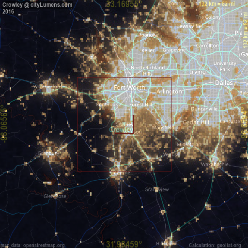
Analysis of Crowley night lights 2016
Square area 10x10 km:
 13.29%
90-99
13.81%80-89
13.11%70-79
15.73%60-69
22.03%50-59
8.39%40-49
7.52%30-39
4.9%20-29
1.22%10-19
0%0-9
0%Square area 50x50 km:
10.03%90-99
11.05%80-89
8.57%70-79
7%60-69
6.68%50-59
7.14%40-49
5.97%30-39
6.02%20-29
7.78%10-19
10.29%0-9
19.48%Clear (daylight) street map image can be seen on geolist.org.
Map coordinates:
33° 10' 10.4" North, 98° 3' 56.3" West
32° 34' 44.5" North, 97° 21' 45.1" West
31° 59' 4.5" North, 96° 39' 33.8" West
Some cities around Crowley sort by population:
• Fort Worth
16.7 km =10.4 mi,  13°
13°
• Burleson
5.7 km =3.5 mi,  136°
136°
• Benbrook
13.9 km =8.6 mi,  318°
318°
• Forest Hill
13.5 km =8.4 mi,  40°
40°
• Rendon
11.4 km =7.1 mi,  91°
91°
• Kennedale
14.9 km =9.3 mi,  59°
59°
• Everman
9 km =5.6 mi,  49°
49°
• Joshua
13.3 km =8.3 mi,  190°
190°
4684434 (p: 14,853)
Sources (retrieved 2019-11-25):
» Earth at Night: Flat Maps 2012, 2016