Gold River night lights from space
Night Light of Gold River (California) from space (United States) Src. Average luminocity for 10x10km area is 71.0162% and for 50x50km: 42.5807%.
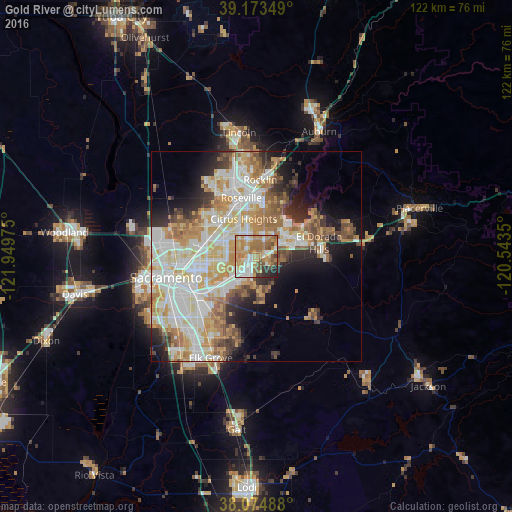
Analysis of Gold River night lights 2016
Square area 10x10 km:
 11.69%
90-99
13.31%80-89
7.63%70-79
22.4%60-69
21.59%50-59
7.63%40-49
4.55%30-39
4.55%20-29
5.36%10-19
1.3%0-9
0%Square area 50x50 km:
9.67%90-99
10.92%80-89
5.28%70-79
7.56%60-69
6.51%50-59
4.35%40-49
3.44%30-39
3.68%20-29
4.92%10-19
7.77%0-9
35.9%Clear (daylight) street map image can be seen on geolist.org.
Map coordinates:
39° 10' 24.6" North, 121° 56' 59.1" West
38° 37' 34.6" North, 121° 14' 47.8" West
38° 4' 29.6" North, 120° 32' 36.6" West
Some cities around Gold River sort by population:
• Citrus Heights
9.5 km =5.9 mi,  341°
341°
• Folsom
8.4 km =5.2 mi,  46°
46°
• Rancho Cordova
6.4 km =4 mi,  229°
229°
• Carmichael
7.2 km =4.5 mi,  261°
261°
• Orangevale
6.1 km =3.8 mi,  17°
17°
• Foothill Farms
10.8 km =6.7 mi,  302°
302°
• Fair Oaks
3 km =1.9 mi,  312°
312°
• La Riviera
11.6 km =7.2 mi,  235°
235°
5352771 (p: 7,912)
Sources (retrieved 2019-11-25):
» Earth at Night: Flat Maps 2012, 2016