Glenn Heights night lights from space
Night Light of Glenn Heights (Texas) from space (United States) Src. Average luminocity for 10x10km area is 73.5385% and for 50x50km: 56.4731%.
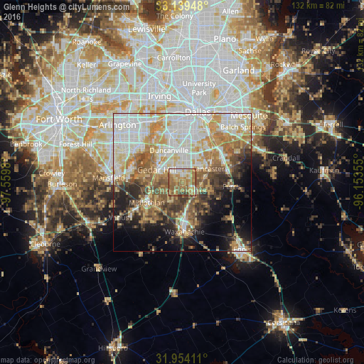
Analysis of Glenn Heights night lights 2016
Square area 10x10 km:
 8.04%
8.04%90-99
12.41%80-89
13.99%70-79
18.53%60-69
26.22%50-59
15.38%40-49
4.02%30-39
1.4%20-29
0%10-19
0%0-9
0%Square area 50x50 km:
13.74%90-99
12.97%80-89
8.26%70-79
8.49%60-69
7.81%50-59
7.73%40-49
5.74%30-39
5.71%20-29
5.33%10-19
8.35%0-9
15.88%Clear (daylight) street map image can be seen on geolist.org.
Map coordinates:
33° 8' 22.1" North, 97° 33' 35.3" West
32° 32' 55.5" North, 96° 51' 24" West
31° 57' 14.8" North, 96° 9' 12.8" West
Some cities around Glenn Heights sort by population:
• DeSoto
4.6 km =2.9 mi,  359°
359°
• Cedar Hill
10.3 km =6.4 mi,  295°
295°
• Duncanville
12.4 km =7.7 mi,  337°
337°
• Lancaster
10.6 km =6.6 mi,  62°
62°
• Waxahachie
18.1 km =11.2 mi,  177°
177°
• Midlothian
14.9 km =9.3 mi,  240°
240°
• Red Oak
6 km =3.7 mi,  125°
125°
• Hutchins
17.5 km =10.9 mi,  50°
50°
4693726 (p: 12,042)
Sources (retrieved 2019-11-25):
» Earth at Night: Flat Maps 2012, 2016