Glencoe night lights from space
Night Light of Glencoe (Minnesota) from space (United States) Src. Average luminocity for 10x10km area is 8.35% and for 50x50km: 2.883%.
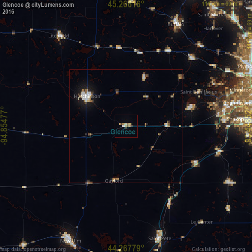
Analysis of Glencoe night lights 2016
Square area 10x10 km:
 0.45%
0.45%90-99
1.21%80-89
1.82%70-79
1.36%60-69
1.52%50-59
0.91%40-49
0.61%30-39
0.91%20-29
0.91%10-19
0.61%0-9
89.7%Square area 50x50 km:
0.35%90-99
0.46%80-89
0.44%70-79
0.33%60-69
0.3%50-59
0.37%40-49
0.36%30-39
0.3%20-29
0.52%10-19
1.69%0-9
94.88%Clear (daylight) street map image can be seen on geolist.org.
Map coordinates:
45° 15' 58.2" North, 94° 51' 17.2" West
44° 46' 8.9" North, 94° 9' 5.9" West
44° 16' 4" North, 93° 26' 54.7" West
Some cities around Glencoe sort by population:
• Hutchinson
21.7 km =13.5 mi,  307°
307°
• Waconia
30.2 km =18.8 mi,  72°
72°
• Mound
42.6 km =26.5 mi,  64°
64°
• Victoria
39.9 km =24.8 mi,  75°
75°
• Minnetrista
39 km =24.2 mi, 61°
• Belle Plaine
34.4 km =21.4 mi,  118°
118°
• Jordan
43 km =26.7 mi,  105°
105°
• Delano
41.7 km =25.9 mi,  43°
43°
5028042 (p: 5,521)
Sources (retrieved 2019-11-25):
» Earth at Night: Flat Maps 2012, 2016