Sycamore night lights from space
Night Light of Sycamore (Illinois) from space (United States) Src. Average luminocity for 10x10km area is 39.4048% and for 50x50km: 13.1272%.
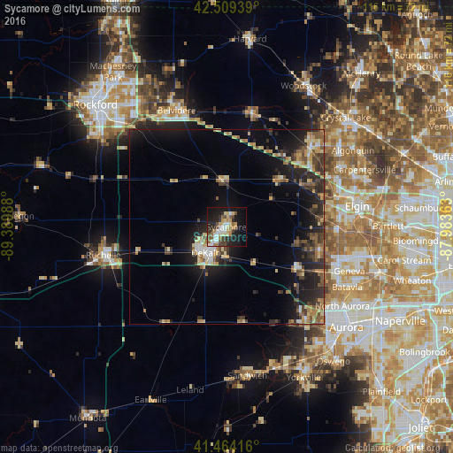
Analysis of Sycamore night lights 2016
Square area 10x10 km:
 5.56%
5.56%90-99
6.51%80-89
7.94%70-79
5.08%60-69
4.44%50-59
3.65%40-49
6.51%30-39
3.49%20-29
12.7%10-19
26.67%0-9
17.46%Square area 50x50 km:
0.83%90-99
1.07%80-89
2.48%70-79
1.77%60-69
1.77%50-59
2.04%40-49
2.2%30-39
2.48%20-29
5.13%10-19
9.58%0-9
70.64%Clear (daylight) street map image can be seen on geolist.org.
Map coordinates:
42° 30' 33.8" North, 89° 23' 23.6" West
41° 59' 20.1" North, 88° 41' 12.3" West
41° 27' 51" North, 87° 59' 1.1" West
Some cities around Sycamore sort by population:
• DeKalb
8.4 km =5.2 mi,  218°
218°
• Wasco
24 km =14.9 mi,  103°
103°
• Village of Campton Hills
24.6 km =15.3 mi, 103°
• Gilberts
28.9 km =18 mi,  63°
63°
• Pingree Grove
24.3 km =15.1 mi,  68°
68°
• Hampshire
17.7 km =11 mi,  46°
46°
• Elburn
20.7 km =12.9 mi,  121°
121°
• Genoa
12.1 km =7.5 mi,  357°
357°
4913110 (p: 17,712)
Sources (retrieved 2019-11-25):
» Earth at Night: Flat Maps 2012, 2016