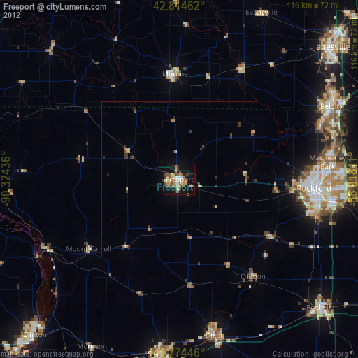
Freeport night lights from space
Night Light of Freeport (Illinois) from space (United States) Src. Average luminocity for 10x10km area is 32.6697% and for 50x50km: 2.4652%.

Analysis of Freeport night lights 2016
Square area 10x10 km:
 3.48%
3.48%90-99
5%80-89
7.88%70-79
3.79%60-69
5%50-59
1.36%40-49
5.76%30-39
1.97%20-29
6.52%10-19
34.85%0-9
24.39%Square area 50x50 km:
0.15%90-99
0.26%80-89
0.56%70-79
0.29%60-69
0.32%50-59
0.29%40-49
0.38%30-39
0.31%20-29
0.7%10-19
1.78%0-9
94.97%Clear (daylight) street map image can be seen on geolist.org.
Map coordinates:
42° 48' 52.6" North, 90° 19' 27.7" West
42° 17' 48.1" North, 89° 37' 16.4" West
41° 46' 28.1" North, 88° 55' 5.2" West
Some cities around Freeport sort by population:
• Rockford
43.5 km =27 mi,  93°
93°
• Loves Park
46.4 km =28.8 mi, 86°
• Machesney Park
48.2 km =30 mi,  83°
83°
• Dixon
52.2 km =32.4 mi,  167°
167°
• Monroe
33.9 km =21.1 mi,  357°
357°
• Roscoe
51.9 km =32.2 mi, 75°
• South Beloit
52.7 km =32.7 mi,  65°
65°
• Rockton
48.3 km =30 mi, 68°
4893171 (p: 24,476)
Sources (retrieved 2019-11-25):
» Earth at Night: Flat Maps 2012, 2016