Roscoe night lights from space
Night Light of Roscoe (Illinois) from space (United States) Src. Average luminocity for 10x10km area is 44.6381% and for 50x50km: 20.3796%.
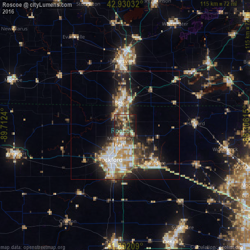
Analysis of Roscoe night lights 2016
Square area 10x10 km:
 2.38%
2.38%90-99
4.13%80-89
6.98%70-79
6.03%60-69
5.87%50-59
8.41%40-49
16.19%30-39
15.87%20-29
19.05%10-19
14.29%0-9
0.79%Square area 50x50 km:
2.75%90-99
3.57%80-89
2.91%70-79
3.04%60-69
3.05%50-59
2.88%40-49
3.44%30-39
3.22%20-29
5.18%10-19
9.05%0-9
60.9%Clear (daylight) street map image can be seen on geolist.org.
Map coordinates:
42° 55' 49.2" North, 89° 42' 44.6" West
42° 24' 48.1" North, 89° 0' 33.4" West
41° 53' 31.5" North, 88° 18' 22.1" West
Some cities around Roscoe sort by population:
• Rockford
17.3 km =10.7 mi,  203°
203°
• Beloit
10.7 km =6.6 mi,  350°
350°
• Belvidere
21.4 km =13.3 mi,  140°
140°
• Loves Park
11.1 km =6.9 mi, 201°
• Machesney Park
7.7 km =4.8 mi, 198°
• South Beloit
9.1 km =5.7 mi, 345°
• Rockton
6.8 km =4.2 mi,  310°
310°
• Poplar Grove
16.2 km =10.1 mi,  108°
108°
4908126 (p: 10,565)
Sources (retrieved 2019-11-25):
» Earth at Night: Flat Maps 2012, 2016