Fostoria night lights from space
Night Light of Fostoria (Ohio) from space (United States) Src. Average luminocity for 10x10km area is 24.5828% and for 50x50km: 9.7748%.
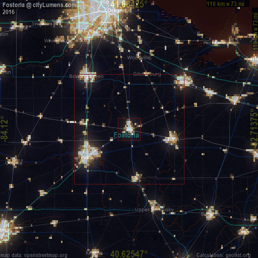
Analysis of Fostoria night lights 2016
Square area 10x10 km:
 3.25%
3.25%90-99
6.01%80-89
2.76%70-79
1.62%60-69
0.97%50-59
2.44%40-49
4.55%30-39
4.06%20-29
4.22%10-19
25.65%0-9
44.48%Square area 50x50 km:
1.3%90-99
1.88%80-89
1.17%70-79
1%60-69
0.93%50-59
1.35%40-49
1.12%30-39
1.34%20-29
1.94%10-19
7.75%0-9
80.22%Clear (daylight) street map image can be seen on geolist.org.
Map coordinates:
41° 41' 3.3" North, 84° 7' 12" West
41° 9' 25.2" North, 83° 25' 0.7" West
40° 37' 31.7" North, 82° 42' 49.5" West
Some cities around Fostoria sort by population:
• Findlay
23.2 km =14.4 mi,  237°
237°
• Bowling Green
31.1 km =19.3 mi,  321°
321°
• Perrysburg
47.8 km =29.7 mi,  338°
338°
• Tiffin
20.6 km =12.8 mi,  103°
103°
• Fremont
32.7 km =20.3 mi,  48°
48°
• Upper Sandusky
38.4 km =23.9 mi,  162°
162°
• Clyde
40.4 km =25.1 mi,  66°
66°
• Waterville
45.8 km =28.5 mi,  326°
326°
5154905 (p: 13,167)
Sources (retrieved 2019-11-25):
» Earth at Night: Flat Maps 2012, 2016