Waxhaw night lights from space
Night Light of Waxhaw (North Carolina) from space (United States) Src. Average luminocity for 10x10km area is 37.5385% and for 50x50km: 40.6147%.
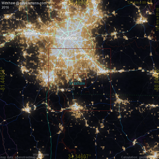
Analysis of Waxhaw night lights 2016
Square area 10x10 km:
 1.28%
1.28%90-99
1.47%80-89
8.24%70-79
7.88%60-69
7.51%50-59
5.49%40-49
9.52%30-39
9.34%20-29
12.64%10-19
23.81%0-9
12.82%Square area 50x50 km:
6.4%90-99
6.9%80-89
8.67%70-79
8.46%60-69
8.17%50-59
3.97%40-49
4.23%30-39
3.87%20-29
5.52%10-19
8.01%0-9
35.8%Clear (daylight) street map image can be seen on geolist.org.
Map coordinates:
35° 29' 56.6" North, 81° 26' 47.5" West
34° 55' 28.5" North, 80° 44' 36.2" West
34° 20' 45.9" North, 80° 2' 25" West
Some cities around Waxhaw sort by population:
• Indian Trail
18.2 km =11.3 mi,  21°
21°
• Monroe
18.9 km =11.7 mi,  69°
69°
• Matthews
21.4 km =13.3 mi,  4°
4°
• Stallings
19.2 km =11.9 mi, 15°
• Fort Mill
20.6 km =12.8 mi,  296°
296°
• Weddington
11 km =6.8 mi,  351°
351°
• Wesley Chapel
11.1 km =6.9 mi,  34°
34°
• Marvin
9.9 km =6.2 mi,  318°
318°
4497833 (p: 13,495)
Sources (retrieved 2019-11-25):
» Earth at Night: Flat Maps 2012, 2016