Ennis night lights from space
Night Light of Ennis (Texas) from space (United States) Src. Average luminocity for 10x10km area is 52.7125% and for 50x50km: 12.5451%.
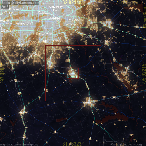
Analysis of Ennis night lights 2016
Square area 10x10 km:
 6.59%
6.59%90-99
10.62%80-89
10.07%70-79
9.71%60-69
7.33%50-59
4.4%40-49
4.21%30-39
14.47%20-29
10.81%10-19
20.51%0-9
1.28%Square area 50x50 km:
0.66%90-99
1.04%80-89
1.67%70-79
2.29%60-69
2.06%50-59
2.54%40-49
2.36%30-39
3.78%20-29
2.71%10-19
7.84%0-9
73.04%Clear (daylight) street map image can be seen on geolist.org.
Map coordinates:
32° 55' 17.4" North, 97° 19' 42.2" West
32° 19' 45.5" North, 96° 37' 31" West
31° 43' 59.6" North, 95° 55' 19.7" West
Some cities around Ennis sort by population:
• DeSoto
36.2 km =22.5 mi,  323°
323°
• Lancaster
31.7 km =19.7 mi,  337°
337°
• Waxahachie
21.9 km =13.6 mi,  286°
286°
• Corsicana
29.9 km =18.6 mi,  150°
150°
• Seagoville
35.4 km =22 mi,  13°
13°
• Glenn Heights
32.7 km =20.3 mi, 318°
• Red Oak
26.9 km =16.7 mi, 321°
• Hutchins
36.5 km =22.7 mi,  346°
346°
4689311 (p: 19,007)
Sources (retrieved 2019-11-25):
» Earth at Night: Flat Maps 2012, 2016