Camden night lights from space
Night Light of Camden (Arkansas) from space (United States) Src. Average luminocity for 10x10km area is 33.8901% and for 50x50km: 3.1863%.
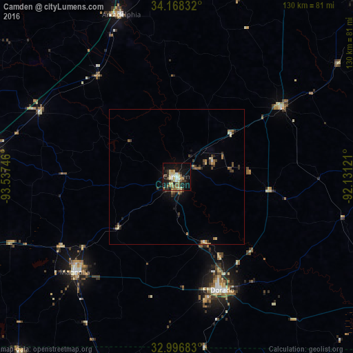
Analysis of Camden night lights 2016
Square area 10x10 km:
 2.01%
2.01%90-99
5.31%80-89
9.34%70-79
1.83%60-69
5.13%50-59
6.78%40-49
2.75%30-39
5.31%20-29
5.31%10-19
35.71%0-9
20.51%Square area 50x50 km:
0.12%90-99
0.32%80-89
0.63%70-79
0.27%60-69
0.54%50-59
0.5%40-49
0.48%30-39
0.74%20-29
0.51%10-19
2.02%0-9
93.86%Clear (daylight) street map image can be seen on geolist.org.
Map coordinates:
34° 10' 6" North, 93° 32' 14.9" West
33° 35' 4.4" North, 92° 50' 3.6" West
32° 59' 48.6" North, 92° 7' 52.4" West
Some cities around Camden sort by population:
• El Dorado
44.7 km =27.8 mi,  159°
159°
• Magnolia
51.6 km =32.1 mi,  226°
226°
• Malvern
86.5 km =53.7 mi,  1°
1°
• Arkadelphia
63 km =39.1 mi,  341°
341°
• Hope
70.7 km =43.9 mi,  277°
277°
• Warren
71.4 km =44.4 mi,  87°
87°
• Crossett
95.7 km =59.5 mi,  122°
122°
• Springhill
87.1 km =54.1 mi,  222°
222°
4104182 (p: 11,347)
Sources (retrieved 2019-11-25):
» Earth at Night: Flat Maps 2012, 2016