Sound Beach night lights from space
Night Light of Sound Beach (New York) from space (United States) Src. Average luminocity for 10x10km area is 35.3316% and for 50x50km: 29.8018%.
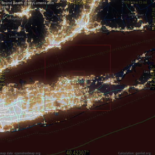
Analysis of Sound Beach night lights 2016
Square area 10x10 km:
 1.02%
1.02%90-99
1.7%80-89
3.91%70-79
4.25%60-69
8.5%50-59
13.27%40-49
9.86%30-39
4.25%20-29
15.48%10-19
22.96%0-9
14.8%Square area 50x50 km:
3.95%90-99
4.85%80-89
4.2%70-79
5.99%60-69
6.02%50-59
5.35%40-49
4.19%30-39
3.02%20-29
5.24%10-19
11.77%0-9
45.42%Clear (daylight) street map image can be seen on geolist.org.
Map coordinates:
41° 29' 6.3" North, 73° 40' 15.6" West
40° 57' 22.4" North, 72° 58' 4.4" West
40° 25' 23.1" North, 72° 15' 53.1" West
Some cities around Sound Beach sort by population:
• Rocky Point
3.6 km =2.2 mi,  96°
96°
• Ridge
9.2 km =5.7 mi,  138°
138°
• Miller Place
2.4 km =1.5 mi,  279°
279°
• Mount Sinai
5.3 km =3.3 mi,  258°
258°
• Middle Island
8.4 km =5.2 mi,  162°
162°
• Port Jefferson
8.6 km =5.3 mi, 262°
• Port Jefferson Station
7.5 km =4.7 mi,  242°
242°
• East Shoreham
7.5 km =4.7 mi, 99°
5138704 (p: 7,612)
Sources (retrieved 2019-11-25):
» Earth at Night: Flat Maps 2012, 2016