Covington night lights from space
Night Light of Covington (Tennessee) from space (United States) Src. Average luminocity for 10x10km area is 34.7784% and for 50x50km: 7.5574%.
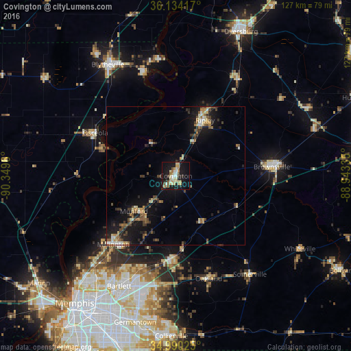
Analysis of Covington night lights 2016
Square area 10x10 km:
 4.21%
4.21%90-99
6.04%80-89
8.97%70-79
3.85%60-69
4.03%50-59
3.3%40-49
2.75%30-39
1.65%20-29
4.21%10-19
42.49%0-9
18.5%Square area 50x50 km:
0.56%90-99
0.84%80-89
1.14%70-79
0.81%60-69
0.9%50-59
1.16%40-49
1.39%30-39
1.29%20-29
1.54%10-19
7.78%0-9
82.6%Clear (daylight) street map image can be seen on geolist.org.
Map coordinates:
36° 8' 3" North, 90° 20' 58.6" West
35° 33' 51.3" North, 89° 38' 47.3" West
34° 59' 24.9" North, 88° 56' 36.1" West
Some cities around Covington sort by population:
• Lakeland
38.1 km =23.7 mi,  192°
192°
• Arlington
29.8 km =18.5 mi,  182°
182°
• Millington
33.6 km =20.9 mi,  222°
222°
• Brownsville
34.9 km =21.7 mi,  84°
84°
• Atoka
18.1 km =11.2 mi, 221°
• Ripley
22.7 km =14.1 mi,  27°
27°
• Osceola
33.1 km =20.6 mi,  298°
298°
• Munford
19.9 km =12.4 mi,  230°
230°
4615804 (p: 9,036)
Sources (retrieved 2019-11-25):
» Earth at Night: Flat Maps 2012, 2016