Anna night lights from space
Night Light of Anna (Texas) from space (United States) Src. Average luminocity for 10x10km area is 22.9895% and for 50x50km: 17.8115%.
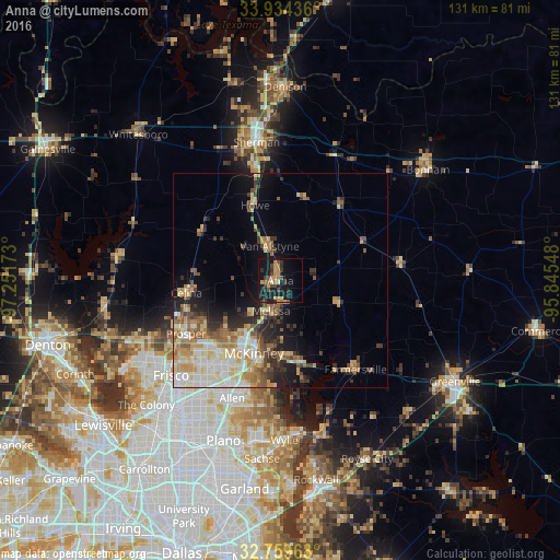
Analysis of Anna night lights 2016
Square area 10x10 km:
 0%
0%90-99
0.87%80-89
2.27%70-79
6.47%60-69
4.02%50-59
2.27%40-49
5.77%30-39
5.59%20-29
4.37%10-19
31.82%0-9
36.54%Square area 50x50 km:
2.6%90-99
3.25%80-89
2.85%70-79
2.71%60-69
2.81%50-59
2.59%40-49
2.09%30-39
2.32%20-29
3.18%10-19
6.84%0-9
68.76%Clear (daylight) street map image can be seen on geolist.org.
Map coordinates:
33° 56' 3.7" North, 97° 15' 6.2" West
33° 20' 56.4" North, 96° 32' 55" West
32° 45' 34.8" North, 95° 50' 43.7" West
Some cities around Anna sort by population:
• McKinney
17.9 km =11.1 mi,  200°
200°
• Allen
29.6 km =18.4 mi, 202°
• Prosper
26.6 km =16.5 mi,  241°
241°
• Princeton
19.4 km =12.1 mi,  165°
165°
• Fairview
22.6 km =14 mi, 199°
• Celina
22.1 km =13.7 mi,  262°
262°
• Melissa
7.4 km =4.6 mi, 197°
• Lucas
29.5 km =18.3 mi,  185°
185°
4670871 (p: 11,463)
Sources (retrieved 2019-11-25):
» Earth at Night: Flat Maps 2012, 2016