Fair Plain night lights from space
Night Light of Fair Plain (Michigan) from space (United States) Src. Average luminocity for 10x10km area is 53.7894% and for 50x50km: 5.615%.
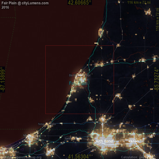
Analysis of Fair Plain night lights 2016
Square area 10x10 km:
 4.39%
4.39%90-99
8.48%80-89
10.61%70-79
8.03%60-69
10.61%50-59
11.06%40-49
15.61%30-39
5.76%20-29
9.7%10-19
14.85%0-9
0.91%Square area 50x50 km:
0.18%90-99
0.48%80-89
1.05%70-79
0.59%60-69
0.8%50-59
1.01%40-49
1.37%30-39
1.1%20-29
1.41%10-19
3.84%0-9
88.17%Clear (daylight) street map image can be seen on geolist.org.
Map coordinates:
42° 36' 23.9" North, 87° 9' 32.4" West
42° 5' 13.2" North, 86° 27' 21.1" West
41° 33' 46.9" North, 85° 45' 9.9" West
Some cities around Fair Plain sort by population:
• South Bend
48 km =29.8 mi,  159°
159°
• Mishawaka
53.3 km =33.1 mi,  152°
152°
• Granger
46.8 km =29.1 mi,  142°
142°
• Niles
33.1 km =20.6 mi, 149°
• Benton Harbor
3.3 km =2.1 mi,  2°
2°
• Saint Joseph
3.2 km =2 mi,  321°
321°
• Notre Dame
46.6 km =29 mi, 157°
• Dowagiac
30.9 km =19.2 mi,  111°
111°
4992394 (p: 7,631)
Sources (retrieved 2019-11-25):
» Earth at Night: Flat Maps 2012, 2016