Notre Dame night lights from space
Night Light of Notre Dame (Indiana) from space (United States) Src. Average luminocity for 10x10km area is 89.013% and for 50x50km: 21.0165%.
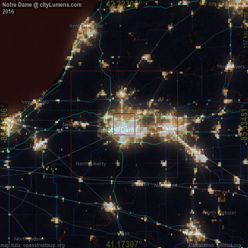
Analysis of Notre Dame night lights 2016
Square area 10x10 km:
 44.64%
90-99
22.24%80-89
4.06%70-79
10.06%60-69
12.5%50-59
5.84%40-49
0.65%30-39
0%20-29
0%10-19
0%0-9
0%Square area 50x50 km:
4.21%90-99
3.47%80-89
1.99%70-79
2.24%60-69
3.2%50-59
3.67%40-49
3.87%30-39
3.11%20-29
4.95%10-19
7.37%0-9
61.92%Clear (daylight) street map image can be seen on geolist.org.
Map coordinates:
42° 13' 22.9" North, 86° 56' 27.8" West
41° 42' 0.7" North, 86° 14' 16.5" West
41° 10' 23.1" North, 85° 32' 5.3" West
Some cities around Notre Dame sort by population:
• South Bend
2.1 km =1.3 mi,  208°
208°
• Elkhart
21.8 km =13.5 mi,  95°
95°
• Mishawaka
7.8 km =4.8 mi,  122°
122°
• Granger
12.1 km =7.5 mi,  60°
60°
• Niles
14.5 km =9 mi,  354°
354°
• Nappanee
34.7 km =21.6 mi,  145°
145°
• Dunlap
27.2 km =16.9 mi, 104°
• Dowagiac
33.3 km =20.7 mi,  18°
18°
8469294 (p: 5,973)
Sources (retrieved 2019-11-25):
» Earth at Night: Flat Maps 2012, 2016