Dormont night lights from space
Night Light of Dormont (Pennsylvania) from space (United States) Src. Average luminocity for 10x10km area is 91.9626% and for 50x50km: 54.0321%.
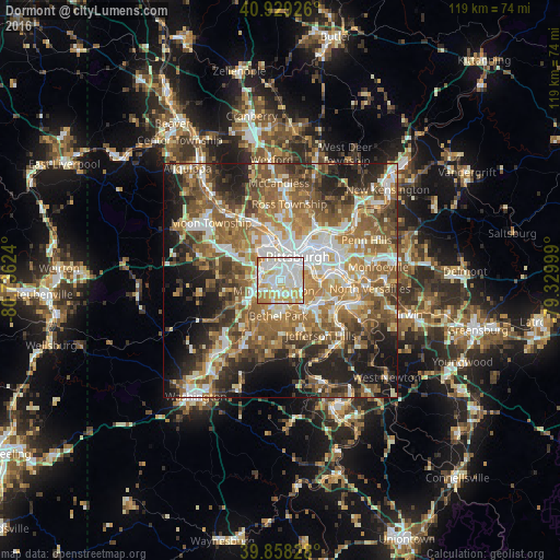
Analysis of Dormont night lights 2016
Square area 10x10 km:
 31.12%
90-99
36.73%80-89
14.46%70-79
13.27%60-69
4.42%50-59
0%40-49
0%30-39
0%20-29
0%10-19
0%0-9
0%Square area 50x50 km:
8.9%90-99
10.12%80-89
6.38%70-79
7.7%60-69
11.17%50-59
11.87%40-49
8.79%30-39
6.67%20-29
9.91%10-19
11.1%0-9
7.38%Clear (daylight) street map image can be seen on geolist.org.
Map coordinates:
40° 55' 45.3" North, 80° 44' 10.5" West
40° 23' 45.2" North, 80° 1' 59.2" West
39° 51' 29.8" North, 79° 19' 48" West
Some cities around Dormont sort by population:
• Pittsburgh
5.9 km =3.7 mi,  32°
32°
• Mount Lebanon
4.7 km =2.9 mi,  197°
197°
• Bethel Park
7.6 km =4.7 mi,  184°
184°
• Whitehall
5.3 km =3.3 mi,  137°
137°
• Brentwood
5.7 km =3.5 mi,  119°
119°
• Castle Shannon
3.6 km =2.2 mi,  165°
165°
• Carnegie
4.5 km =2.8 mi,  288°
288°
• Crafton
5.2 km =3.2 mi,  327°
327°
5187150 (p: 8,465)
Sources (retrieved 2019-11-25):
» Earth at Night: Flat Maps 2012, 2016