Bethel Park night lights from space
Night Light of Bethel Park (Pennsylvania) from space (United States) Src. Average luminocity for 10x10km area is 73.2415% and for 50x50km: 50.8499%.
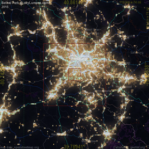

Analysis of Bethel Park night lights 2016
Square area 10x10 km:
 6.97%
6.97%90-99
14.46%80-89
8.16%70-79
19.05%60-69
32.31%50-59
17.01%40-49
2.04%30-39
0%20-29
0%10-19
0%0-9
0%Square area 50x50 km:
8.55%90-99
9.62%80-89
6.27%70-79
7.54%60-69
10.46%50-59
10.35%40-49
7.26%30-39
6.09%20-29
8.63%10-19
12.01%0-9
13.23%Clear (daylight) street map image can be seen on geolist.org.
Map coordinates:
40° 51' 41.3" North, 80° 44' 33.5" West
40° 19' 39.3" North, 80° 2' 22.2" West
39° 47' 21.9" North, 79° 20' 11" West
Some cities around Bethel Park sort by population:
• Mount Lebanon
3.2 km =2 mi,  344°
344°
• Baldwin
5.3 km =3.3 mi,  77°
77°
• Upper Saint Clair
3.8 km =2.4 mi,  283°
283°
• Whitehall
5.6 km =3.5 mi,  47°
47°
• South Park Township
5 km =3.1 mi,  129°
129°
• Pleasant Hills
6.7 km =4.2 mi, 82°
• Castle Shannon
4.4 km =2.7 mi,  19°
19°
• Bryn Mawr
4.8 km =3 mi,  236°
236°
5180199 (p: 32,118)
Sources (retrieved 2019-11-25):
» Earth at Night: Flat Maps 2012, 2016