Dighton night lights from space
Night Light of Dighton (Massachusetts) from space (United States) Src. Average luminocity for 10x10km area is 21.297% and for 50x50km: 35.8161%.
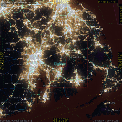
Analysis of Dighton night lights 2016
Square area 10x10 km:
 0%
0%90-99
1.06%80-89
1.06%70-79
0.45%60-69
2.42%50-59
4.55%40-49
4.09%30-39
3.64%20-29
17.42%10-19
47.27%0-9
18.03%Square area 50x50 km:
5.13%90-99
5.64%80-89
3.96%70-79
3.71%60-69
5.12%50-59
6.49%40-49
7.1%30-39
7.39%20-29
13.53%10-19
16.95%0-9
24.96%Clear (daylight) street map image can be seen on geolist.org.
Map coordinates:
42° 20' 9.2" North, 71° 49' 24.4" West
41° 48' 50.4" North, 71° 7' 13.2" West
41° 17' 16.1" North, 70° 25' 1.9" West
Some cities around Dighton sort by population:
• Fall River
12.8 km =8 mi,  192°
192°
• Taunton
9.9 km =6.2 mi,  14°
14°
• Somerset
5 km =3.1 mi, 187°
• Swansea
9.3 km =5.8 mi,  218°
218°
• Raynham
15.5 km =9.6 mi, 14°
• Rehoboth
11.1 km =6.9 mi,  285°
285°
• Freetown
9 km =5.6 mi,  125°
125°
• Berkley
4.7 km =2.9 mi,  41°
41°
4934827 (p: 6,283)
Sources (retrieved 2019-11-25):
» Earth at Night: Flat Maps 2012, 2016