Bogalusa night lights from space
Night Light of Bogalusa (Louisiana) from space (United States) Src. Average luminocity for 10x10km area is 38.0664% and for 50x50km: 4.9223%.
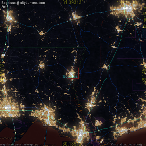
Analysis of Bogalusa night lights 2016
Square area 10x10 km:
 4.37%
4.37%90-99
4.72%80-89
7.69%70-79
6.99%60-69
7.52%50-59
1.4%40-49
5.77%30-39
6.99%20-29
5.94%10-19
29.55%0-9
19.06%Square area 50x50 km:
0.18%90-99
0.2%80-89
0.76%70-79
0.67%60-69
0.69%50-59
0.5%40-49
1.18%30-39
1.64%20-29
1.32%10-19
3.91%0-9
88.95%Clear (daylight) street map image can be seen on geolist.org.
Map coordinates:
31° 23' 35.3" North, 90° 33' 6.6" West
30° 47' 27.7" North, 89° 50' 55.3" West
30° 11' 6.4" North, 89° 8' 44.1" West
Some cities around Bogalusa sort by population:
• Slidell
57.7 km =35.9 mi,  173°
173°
• Carriere
27 km =16.8 mi,  135°
135°
• Mandeville
52.4 km =32.6 mi,  203°
203°
• Picayune
33.7 km =20.9 mi,  151°
151°
• Covington
42.6 km =26.5 mi,  214°
214°
• Lacombe
53.9 km =33.5 mi,  189°
189°
• Holly Springs
59.6 km =37 mi,  348°
348°
• Columbia
51.2 km =31.8 mi,  1°
1°
4317412 (p: 11,933)
Sources (retrieved 2019-11-25):
» Earth at Night: Flat Maps 2012, 2016