Contra Costa Centre night lights from space
Night Light of Contra Costa Centre (California) from space (United States) Src. Average luminocity for 10x10km area is 64.7354% and for 50x50km: 37.8764%.
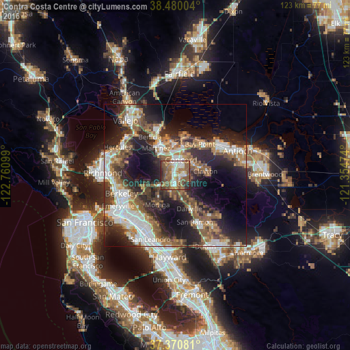
Analysis of Contra Costa Centre night lights 2016
Square area 10x10 km:
 11.53%
90-99
11.36%80-89
5.84%70-79
5.84%60-69
16.07%50-59
24.03%40-49
12.66%30-39
5.84%20-29
6.82%10-19
0%0-9
0%Square area 50x50 km:
7.28%90-99
6.53%80-89
2.15%70-79
4.64%60-69
6.21%50-59
7.61%40-49
6.58%30-39
5.45%20-29
12.76%10-19
15.51%0-9
25.3%Clear (daylight) street map image can be seen on geolist.org.
Map coordinates:
38° 28' 48.1" North, 122° 45' 39.6" West
37° 55' 39.1" North, 122° 3' 28.3" West
37° 22' 14.9" North, 121° 21' 17.1" West
Some cities around Contra Costa Centre sort by population:
• Concord
6.1 km =3.8 mi,  22°
22°
• Walnut Creek
2.4 km =1.5 mi,  194°
194°
• Pleasant Hill
2.3 km =1.4 mi,  353°
353°
• Lafayette
7 km =4.3 mi,  228°
228°
• Alamo
8.9 km =5.5 mi,  165°
165°
• Clayton
10.8 km =6.7 mi,  82°
82°
• Waldon
0.2 km =0.1 mi,  123°
123°
• Saranap
5 km =3.1 mi,  198°
198°
8097232 (p: 5,364)
Sources (retrieved 2019-11-25):
» Earth at Night: Flat Maps 2012, 2016