College Station night lights from space
Night Light of College Station (Texas) from space (United States) Src. Average luminocity for 10x10km area is 89.5769% and for 50x50km: 13.0417%.
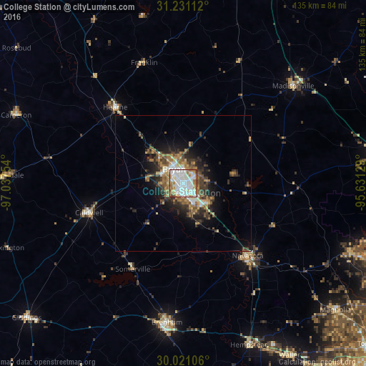


Analysis of College Station night lights 2016
Square area 10x10 km:
 35.66%
90-99
32.69%80-89
6.64%70-79
7.87%60-69
11.71%50-59
3.32%40-49
1.57%30-39
0.52%20-29
0%10-19
0%0-9
0%Square area 50x50 km:
1.96%90-99
2.2%80-89
1.28%70-79
1.49%60-69
2.34%50-59
1.97%40-49
2.11%30-39
2.55%20-29
3.37%10-19
5.57%0-9
75.15%Clear (daylight) street map image can be seen on geolist.org.
Map coordinates:
31° 13' 52" North, 97° 2' 15.1" West
30° 37' 40.7" North, 96° 20' 3.9" West
30° 1' 15.8" North, 95° 37' 52.6" West
Some cities around College Station sort by population:
• Bryan
6.2 km =3.9 mi,  326°
326°
• Huntsville
75.7 km =47 mi,  81°
81°
• Brenham
51.6 km =32.1 mi,  186°
186°
• Navasota
35.6 km =22.1 mi,  138°
138°
• Hempstead
63.9 km =39.7 mi,  157°
157°
• Prairie View
68.1 km =42.3 mi,  150°
150°
• Rockdale
63.9 km =39.7 mi,  272°
272°
• Cameron
66.3 km =41.2 mi,  292°
292°
4682464 (p: 107,889)
Sources (retrieved 2019-11-25):
» NASA, Earths city lights 1995
» NASA city lights 2003
» Earth at Night: Flat Maps 2012, 2016