Cold Spring Harbor night lights from space
Night Light of Cold Spring Harbor (New York) from space (United States) Src. Average luminocity for 10x10km area is 54.7296% and for 50x50km: 54.9652%.
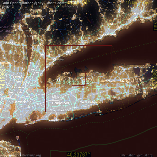
Analysis of Cold Spring Harbor night lights 2016
Square area 10x10 km:
 5.61%
5.61%90-99
6.63%80-89
7.31%70-79
8.84%60-69
9.52%50-59
21.94%40-49
14.29%30-39
4.93%20-29
9.52%10-19
10.88%0-9
0.51%Square area 50x50 km:
17.74%90-99
12.77%80-89
6.45%70-79
7.35%60-69
7.52%50-59
6.15%40-49
3.59%30-39
2.92%20-29
5.77%10-19
8.7%0-9
21.03%Clear (daylight) street map image can be seen on geolist.org.
Map coordinates:
41° 24' 3.7" North, 74° 9' 35.7" West
40° 52' 17.4" North, 73° 27' 24.4" West
40° 20' 15.6" North, 72° 45' 13.2" West
Some cities around Cold Spring Harbor sort by population:
• Huntington Station
4.3 km =2.7 mi,  117°
117°
• Syosset
6.3 km =3.9 mi,  217°
217°
• Huntington
2.6 km =1.6 mi,  98°
98°
• South Huntington
7.2 km =4.5 mi,  137°
137°
• Woodbury
5.2 km =3.2 mi,  190°
190°
• Oyster Bay
6.4 km =4 mi,  264°
264°
• West Hills
6.5 km =4 mi,  161°
161°
• Centerport
6.9 km =4.3 mi,  77°
77°
5113223 (p: 5,070)
Sources (retrieved 2019-11-25):
» Earth at Night: Flat Maps 2012, 2016