Clinton night lights from space
Night Light of Clinton (South Carolina) from space (United States) Src. Average luminocity for 10x10km area is 40.5437% and for 50x50km: 9.6639%.
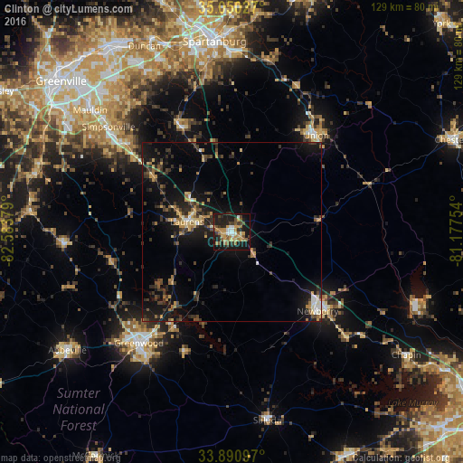
Analysis of Clinton night lights 2016
Square area 10x10 km:
 4.2%
4.2%90-99
3.5%80-89
4.72%70-79
10.84%60-69
7.52%50-59
5.24%40-49
6.12%30-39
5.77%20-29
12.59%10-19
36.19%0-9
3.32%Square area 50x50 km:
0.5%90-99
0.63%80-89
1.14%70-79
1.59%60-69
1.41%50-59
0.87%40-49
1.62%30-39
2.95%20-29
2.99%10-19
9.98%0-9
76.31%Clear (daylight) street map image can be seen on geolist.org.
Map coordinates:
35° 3' 1" North, 82° 35' 1.6" West
34° 28' 21.5" North, 81° 52' 50.4" West
33° 53' 27.5" North, 81° 10' 39.1" West
Some cities around Clinton sort by population:
• Mauldin
52 km =32.3 mi,  310°
310°
• Greenwood
40.2 km =25 mi,  219°
219°
• Simpsonville
45.1 km =28 mi, 310°
• Five Forks
48.8 km =30.3 mi,  319°
319°
• Newberry
32.6 km =20.3 mi,  132°
132°
• Laurens
12.6 km =7.8 mi,  283°
283°
• Fountain Inn
37.6 km =23.4 mi, 309°
• Union
35.8 km =22.2 mi,  41°
41°
4575028 (p: 8,637)
Sources (retrieved 2019-11-25):
» Earth at Night: Flat Maps 2012, 2016