Newberry night lights from space
Night Light of Newberry (South Carolina) from space (United States) Src. Average luminocity for 10x10km area is 44.6886% and for 50x50km: 6.0029%.
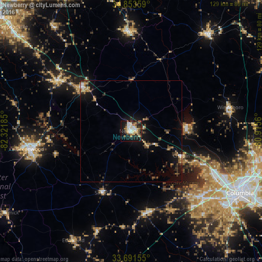
Analysis of Newberry night lights 2016
Square area 10x10 km:
 7.33%
7.33%90-99
9.52%80-89
7.14%70-79
5.86%60-69
7.88%50-59
2.38%40-49
3.11%30-39
7.33%20-29
11.17%10-19
30.22%0-9
8.06%Square area 50x50 km:
0.5%90-99
0.56%80-89
0.7%70-79
0.78%60-69
0.93%50-59
0.62%40-49
0.86%30-39
1.44%20-29
1.34%10-19
5.58%0-9
86.68%Clear (daylight) street map image can be seen on geolist.org.
Map coordinates:
34° 51' 12.9" North, 82° 19' 18.7" West
34° 16' 28.5" North, 81° 37' 7.4" West
33° 41' 29.6" North, 80° 54' 56.2" West
Some cities around Newberry sort by population:
• Lexington
48 km =29.8 mi,  132°
132°
• Seven Oaks
50.2 km =31.2 mi,  120°
120°
• Irmo
45.2 km =28.1 mi, 117°
• Laurens
44 km =27.3 mi,  304°
304°
• Clinton
32.6 km =20.3 mi,  312°
312°
• Union
49 km =30.4 mi,  359°
359°
• Lake Murray of Richland
36.8 km =22.9 mi, 117°
• Batesburg-Leesville
41.2 km =25.6 mi,  169°
169°
4589207 (p: 10,331)
Sources (retrieved 2019-11-25):
» Earth at Night: Flat Maps 2012, 2016