Chester night lights from space
Night Light of Chester (Illinois) from space (United States) Src. Average luminocity for 10x10km area is 20.4058% and for 50x50km: 4.3022%.
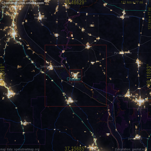
Analysis of Chester night lights 2016
Square area 10x10 km:
 1.95%
1.95%90-99
1.79%80-89
5.03%70-79
3.08%60-69
1.79%50-59
2.11%40-49
3.25%30-39
2.76%20-29
2.27%10-19
13.64%0-9
62.34%Square area 50x50 km:
0.38%90-99
0.48%80-89
0.71%70-79
0.57%60-69
0.53%50-59
0.65%40-49
0.59%30-39
0.75%20-29
0.55%10-19
2.22%0-9
92.57%Clear (daylight) street map image can be seen on geolist.org.
Map coordinates:
38° 27' 58.6" North, 90° 31' 30.6" West
37° 54' 49.2" North, 89° 49' 19.4" West
37° 21' 24.7" North, 89° 7' 8.1" West
Some cities around Chester sort by population:
• Carbondale
57.1 km =35.5 mi,  111°
111°
• Farmington
54.7 km =34 mi,  254°
254°
• Jackson
60.7 km =37.7 mi,  166°
166°
• Waterloo
55 km =34.2 mi,  328°
328°
• Perryville
21.3 km =13.2 mi,  189°
189°
• Murphysboro
45.9 km =28.5 mi, 111°
• Du Quoin
52.5 km =32.6 mi,  78°
78°
• Pinckneyville
42.8 km =26.6 mi,  64°
64°
4235724 (p: 8,588)
Sources (retrieved 2019-11-25):
» Earth at Night: Flat Maps 2012, 2016