Wadesboro night lights from space
Night Light of Wadesboro (North Carolina) from space (United States) Src. Average luminocity for 10x10km area is 26.9982% and for 50x50km: 4.0851%.
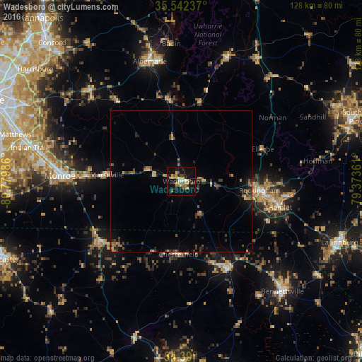
Analysis of Wadesboro night lights 2016
Square area 10x10 km:
 1.28%
1.28%90-99
1.65%80-89
5.86%70-79
5.13%60-69
6.23%50-59
2.56%40-49
3.11%30-39
2.38%20-29
5.31%10-19
34.98%0-9
31.5%Square area 50x50 km:
0.07%90-99
0.07%80-89
0.55%70-79
0.7%60-69
0.77%50-59
0.46%40-49
0.63%30-39
1.14%20-29
1.01%10-19
2.81%0-9
91.8%Clear (daylight) street map image can be seen on geolist.org.
Map coordinates:
35° 32' 32.5" North, 80° 46' 47.5" West
34° 58' 5.6" North, 80° 4' 36.2" West
34° 23' 24" North, 79° 22' 25" West
Some cities around Wadesboro sort by population:
• Monroe
43.1 km =26.8 mi,  272°
272°
• Albemarle
43.9 km =27.3 mi,  345°
345°
• Rockingham
27.8 km =17.3 mi,  96°
96°
• Bennettsville
52.9 km =32.9 mi,  137°
137°
• Wesley Chapel
54.6 km =33.9 mi, 274°
• Unionville
41.5 km =25.8 mi,  288°
288°
• Hamlet
36.1 km =22.4 mi, 104°
• Cheraw
34.9 km =21.7 mi,  149°
149°
4497244 (p: 5,584)
Sources (retrieved 2019-11-25):
» Earth at Night: Flat Maps 2012, 2016