Bellbrook night lights from space
Night Light of Bellbrook (Ohio) from space (United States) Src. Average luminocity for 10x10km area is 38.4903% and for 50x50km: 38.1948%.
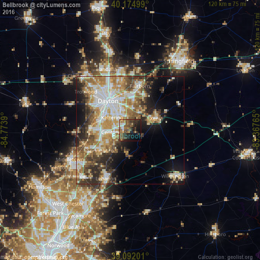
Analysis of Bellbrook night lights 2016
Square area 10x10 km:
 3.25%
3.25%90-99
3.41%80-89
2.44%70-79
4.71%60-69
7.95%50-59
12.82%40-49
11.2%30-39
9.74%20-29
11.04%10-19
19.81%0-9
13.64%Square area 50x50 km:
6.99%90-99
7.9%80-89
5.09%70-79
5.9%60-69
6.56%50-59
5.45%40-49
5.36%30-39
5.15%20-29
6.69%10-19
8.9%0-9
36.01%Clear (daylight) street map image can be seen on geolist.org.
Map coordinates:
40° 10' 30" North, 84° 46' 26" West
39° 38' 8.2" North, 84° 4' 14.8" West
39° 5' 31.2" North, 83° 22' 3.5" West
Some cities around Bellbrook sort by population:
• Kettering
10.3 km =6.4 mi,  305°
305°
• Beavercreek
8.2 km =5.1 mi,  4°
4°
• Xenia
13.3 km =8.3 mi,  65°
65°
• Centerville
7.6 km =4.7 mi,  263°
263°
• Springboro
16.7 km =10.4 mi,  236°
236°
• West Carrollton City
16.1 km =10 mi,  284°
284°
• Oakwood
13.3 km =8.3 mi,  318°
318°
• Moraine
14.9 km =9.3 mi,  301°
301°
4506166 (p: 7,053)
Sources (retrieved 2019-11-25):
» Earth at Night: Flat Maps 2012, 2016